I wanted to post this as a reply to my previous Blog Post: MH370 – What I Think Happened After I Saw It (Do check the replies here, this is where I am adding in links which support my sighting, as I come across them). I can’t attach images in a reply though, and I do want to show you this one:

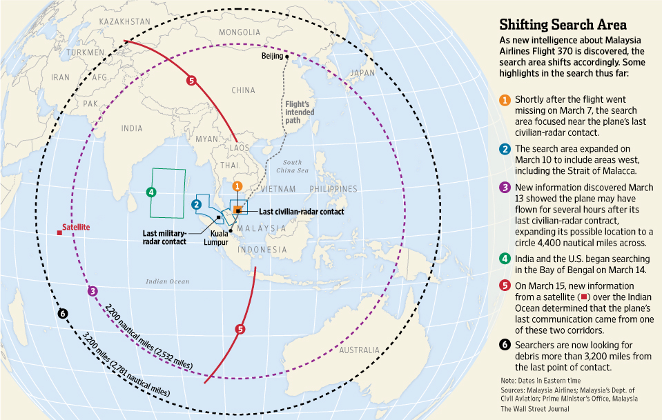
It’s from an article in the Wall Street Journal back in March, just a few weeks after the aircraft disappeared: Critical Data Was Delayed in Search for Missing Malaysia Airlines Flight
Now, I never really thought about why they were searching the Bay of Bengal – I just assumed it was just a random miscommunication, which so often seems to happen in Asia. But back then, as far as we knew, the aircraft hooked around Bandeh Aceh then headed South, and this fitted perfectly with Flight Engineer Stewart Stoddart’s report suggesting the plane was suffering an engine fire, and went down further North up that arc than the ‘experts’ thought, but still on that same arc, which is all they know about where the plane ended it’s flight.
But a few months ago, the Inmarsat data was recalculated, and gave new positions for the arcs which the aircraft supposedly crossed. And that threw his careful research out. His simulated flights, which had matched ALL the data perfectly, were redundant. But he kept going and made a new flight profile. It had changed the profile so drastically that he could only fit the timings of those arcs if he threw in an approach to Car Nicobar (and remember, my sighting is consistent with an abandoned approach to Bandeh Aceh).

I saw it, accepted it, and moved on. But having seen this article in The WSJ today, it makes me wonder if they DID have good reason for searching up there. They somehow tracked MH370 up that airway, N571 (commonly used for passages to Tehran, coincidentally), before they lost it, and THAT’S why they were searching up there.
This wasn’t a random miscommunication. This was an informed search based on their last known data, before they started to hide things and introduce red herrings to distract us all from the truth.
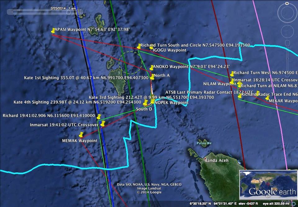
Edit: More graphic images of the projected flight paths from Stewart AND Richard Godfrey (which both fit with my sighting, radar data AND Inmarsat data) can be downloaded in pdf from here: Stoddart Dropbox
The Examiner refers to route N571: http://www.examiner.com/article/malaysia-flight-mh370-amid-rumors-of-found-wreckage-plane-may-be-declared-lost
one of the reasons the Bay of Bengal became a focus was an oil prospecting company turned its machines from search for oil under the water to sniffing for avgas and aviation oil in the water surface
they hit a target and suggested to the searchers to review there data- this was not followed up until now
I’m not sure I understand what you’re saying. Can you elaborate a little? Also, do you have links to sources?
if you google any part of below it will show further info–
An Adelaide-based exploration company believes it may have located the wreckage of Malaysia Airlines flight MH370, 5000km away from where authorities have been looking.
The company, GeoResonance, says its research has identified elements on the ocean floor consistent with material from a plane.
Six weeks have now passed since the plane disappeared and extensive searches in the Indian Ocean have failed to locate any wreckage.
Today, Prime Minister Tony Abbott admitted the chance of finding debris on the surface is slim to none.
ahhh hold on Kate
I have found more about and its very suspicious about the claims-
https://www.metabunk.org/threads/debunked-exploration-company-georesonance-believes-it-may-have-found-mh370.3558/
this website debunks all the above that I said!! looks like I am wrong 100%
Hi David. Thank you for your contribution. Every little helps. I recall the Georesonance name, but didn’t really pay any attention. However, I don’t believe they were as corrupt as Metabunk claims! I believe they found something, and it was worth investigating. But here is one thing I found:
“GeoResonance stands by its claim that we have located what appears to be the wreck of an aircraft 190km South of the Bangladesh coastline in 1,000 to 1,100 metres of water. We have never claimed this to be MH370, however it is a lead that must be thoroughly followed through.” http://www.globalresearch.ca/the-search-for-malaysian-airlines-mh370-wreck-of-unidentified-aircraft-in-bay-of-bengal-crucial-information-withheld/5389187
This location means it cannot have been MH370, if what I saw was MH370. The plane I saw was moving southwards from my position just North of Bandeh Aceh. It was at low altitude. It was moving slowly. I’m not an aviation expert, but I don’t believe it could have gone much further than that military convoy it was heading towards. And why DIDN’T that military convoy report seeing this plane on their radar?